SC23 Harita 1.0.0.0
Professional map plugin that collects field size, CAD drawing production, elevation, surface, route and output processes in a single panel. SC23 Map collects repetitive operations on CAD in a single…
Professional map plugin that collects field size, CAD drawing production, elevation, surface, route and output processes in a single panel. SC23 Map collects repetitive operations on CAD in a single…
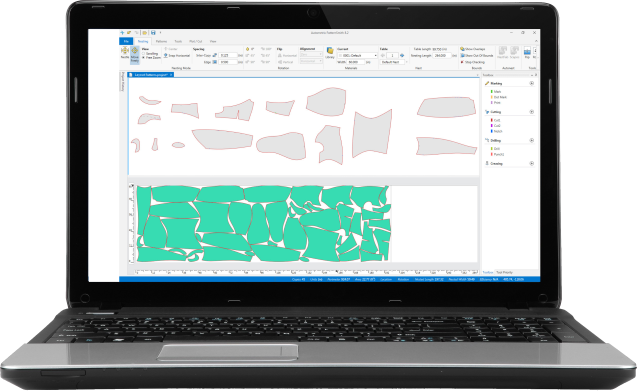
PatternSmith is a 2D drafting system built specifically for textile pattern creation and management. Organize and nest patterns. Import files from other systems and export files to your cutting machine.…

Spatial Manager™ for ZWCAD is a powerful ZWCAD plug-in designed for ZWCAD users who need to import, export, transform and manage spatial data in a simple, fast and inexpensive way,…

Spatial Manager™ for BricsCAD is a powerful BricsCAD plug-in designed for BricsCAD users who need to import, export, transform and manage spatial data in a simple, fast and inexpensive way,…

Spatial Manager Desktop is a comprehensive and reliable software solution that was developed to assist you in successfully managing spatial data necessary in planning, infrastructure or construction projects. Neatly-structured and…

Spatial Manager™ for GstarCAD is a powerful GstarCAD plug-in designed for GstarCAD users who need to import, export, transform and manage spatial data in a simple, fast and inexpensive way,…
Spatial Manager™ for AutoCAD is a powerful AutoCAD plug-in designed for AutoCAD users who need to import, export, transform and manage spatial data in a simple, fast and inexpensive way,…
TBN2C3D is a plugin package with various functions for Autodesk Civil 3D, which automate actions on multiple points, alignments, profiles, corridors, and material lists. Extraction of service notes Representation of…
What is TBN2CAD? TBN2CAD is a plugin package for AutoCAD, BricsCAD, ZwCAD, and GstarCAD. Plugins are available for: Exporting CAD drawing elements to Google Earth KML/KMZ files Importing KML/KMZ files…

Analist 2027 is the professional software for land surveying and design, compatible with Total Stations, GNSS, Drones, and Laser Scanners. Analist 2027 is the complete software for surveyors, engineers, architects,…